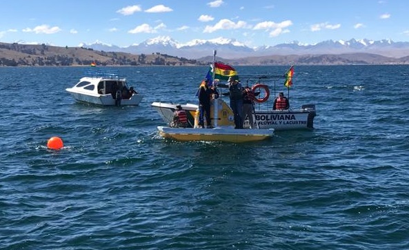
Bolivia deployed the first buoy
automatic hydro-meteorological monitoring buoy
in the Lesser Lake Titicaca on June 28, 2019.
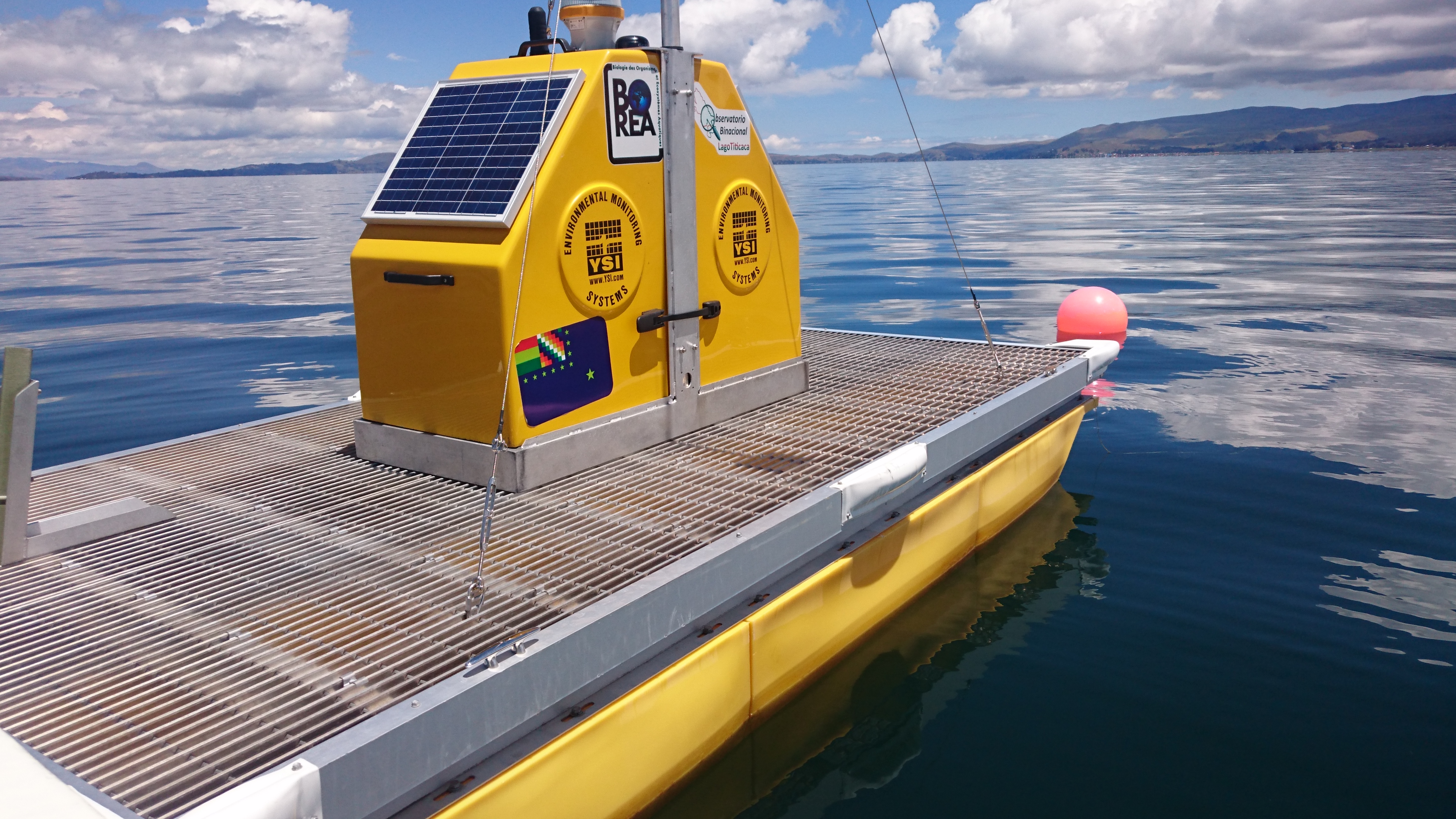
On Thursday, June 27, 2019, a truck unloaded on a beach in Huatajata two huge boxes containing more than a ton of state-of-the-art electronic equipment. A group of university specialists, Dr. Xavier Lazzaro, IRD-France researcher, MSc. Viviana E. Cruz Hernández, William G. Lanza Aguilar and Javier A. Maldonado Alfaro, young associate researchers from the Institute of Ecology (IE) and the Institute of Geographic Research (IIGEO) of the UMSA, with the technical support of Eng. Pierre Sterling, sales director of the manufacturer XYLEM Analytics Inc./USA for Central and South America, assembled and deployed the first autonomous buoy-platform for monitoring automatic high-frequency monitoring of water quality and meteorological conditions of Lake Titicaca!
Why an automatic autonomous buoy?
The Titicaca Minor Lake, especially its shallow littoral areas, is heavily impacted by the effects of climate change and human activities, especially domestic and industrial pollution from the city of El Alto, through the basin of El Alto. of El Alto, through the Katari river basin and Cohana bay.
Global warming, nitrogen, phosphorus and organic matter inputs alter the biogeochemical and ecological functioning and aquatic biodiversity, putting in danger of extinction the mostly endemic species (native or local) of the Altiplano. Consequently, the constant supply of nutrients and organic matter increases the level of productivity of the lake's algae. In fact, during the day through photosynthesis, with such intense solar radiation at an altitude of almost 4,000 m, the microalgae of the phytoplankton, are the first to benefit from the nutrients input, increasing their biomass and oxygenating the water column. These primary producers are the basis of the aquatic food chain. Bacteria mineralize organic matter and, conversely, consume dissolved oxygen. Some can produce toxic gases, as is the case with sulfate-reducing bacteria that produce a neuroleukocyte gas, reducing bacteria that produce a potent neurotoxic gas, hydrogen sulfide (H2S), which smells like rotten eggs.

Launching of the hydro-meteorological buoy on the shore of Huatajata.
At night, the respiration of consumers (zooplankton, macro-invertebrates, fish, among others) also depletes oxygen, which can become limiting in the early morning. In extreme conditions, certain green microalgae and cyanobacteria can proliferate. They form a surface layer ('bloom') that does not allow solar radiation to pass through at depth and inhibits oxygen exchanges with the atmosphere. The lack of light at the bottom is detrimental to the survival of submerged plants (macrophytes). (macrofitas) submerged, such as charas, which also consume nutrients and oxygenate the water. All around, the reduction of dissolved oxygen, already reduced by 30% by the altitude in relation to sea level, is deadly for these consumers.

Diagram of the conditions of Lake Minor Titicaca: A) Undisturbed conditions: Phytoplankton not very abundant on the surface, submerged Charas in good condition, good oxygenation (O2 ). B) During the 2015 acute eutrophication event: massive nutrient inputs (NO3, PO4 ), fitoplankton bloom (green surface layer), deoxygenation, increased carbon dioxide (CO2 ), release of hydrogen sulfide (H2S) toxic to aquatic life, collapse of Charas
The evolution of this subtle balance of processes deserves to be studied in order to anticipate future responses of the lake, and to develop measures to control undesirable phenomena. For this, it is necessary to monitor the behavior of key parameters in the water. The most important of these are: dissolved oxygen concentration (-), temperature gradient (+) (increasing temperature reduces oxygen solubility), dissolved organic matter concentration (+), transparency (-), and dissolved organic matter concentration (-). (+), transparency (-) or turbidity (+), pH (+), concentration in chlorophyll-a the major photosynthetic pigment of algae (+), proportion and concentration of cyanobacteria in phytoplankton (+), conductivity (+). (+). The increase (+) or decrease (-) of these parameters reveals a deterioration of water quality, called 'eutrophication'. This does not take into account the pollutants themselves. These parameters are influenced by atmospheric atmospheric conditions, such as: the strength of the wind capable of mixing and cooling the water column, the intensity of solar radiation (altered by cloud cover) which heats the surface, the atmospheric pressure which regulates the dissolution of oxygen, rainfall (rain, snow, hail) that provides nutrients, among others. The responses of microorganisms (micro-algae, bacteria) to variations in environmental conditions are extremely rapid. are extremely fast. They are capable of doubling their densities in hours or days. Measurement and sample collection campaigns are time consuming, require logistics (vehicle, boat, equipment) and are costly. They can only be performed 1-2 times per month, and in part of the year. This is insufficient to anticipate the dynamics of these organisms and eutrophication phenomena. For this reason, it is necessary to complement the regular campaigns at a few representative stations with high frequency automatic sampling of the entire water column at a central station that integrates the variability of conditions in the area of interest. Advances in technology, improved technology, improved sensitivity and miniaturization of sensors, reliability of probes, robotics, computer programming, Internet, speed and coverage of the cellular network, increased efficiency of solar panels, now allow the design of perfectly autonomous and automatic platforms. The buoy deployed in Lago Menor is the example. Data transmission via ENTEL's cellular network to our servers at the UMSA in La Paz, Bolivia, UMSA in La Paz, allows us to have a near real-time view of the lake, and to take action if necessary. With this technology, Lake Titicaca is now instrumented (equipped) like most of the other Great Lakes of the world.
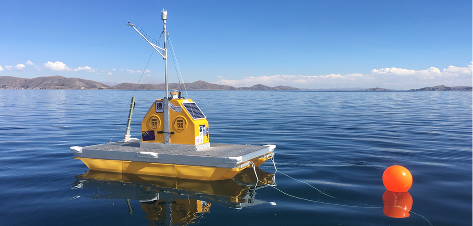
Where is 'My Buoy' located?
The Northeast region is the shallowest, most populated region of Minor Lake, where the phytoplankton microalgal bloom occurred in April-May 2015. In this region, the daily warming of the shallow water mass invariably causes early afternoon thermal winds that increase in intensity. They can reach speeds of up to 10 m/s, sufficient to mix the water column down to 5 m depth. This mixing causes the resuspension of nutrients and organic matter deposited on the bottom. This phenomenon makes this region the most favorable for generating blooms of phytoplankton microalgae. For this reason, it was chosen to deploy the buoy. It is anchored at a depth of 11 m, possibly in the ex-bed of the northern arm of the Katari River, in a zone of 8 m depth on average. This location allows us to study the dynamics of the of daily vertical gradients in dissolved oxygen, temperature, organic matter and chlorophyll-a, generated by meteorological conditions.
Location of the buoy in the northeastern region of Titicaca Minor Lake, Bolivian sector, 4 km south of Huatajata and 10 km west of Puerto Perez'.
The inaugural Lake Ceremony of 'Mi Buoy'.
To present 'Mi Buoy' and its operation to State institutions, local authorities and the lacustrine populations, an inaugural lake ceremony was organized on Friday, June 28, 2019. Since this buoy measures both hydrobiological and meteorological parameters
and meteorological parameters, it was called 'HidroMet Buoy' in technical language. For the general public it is 'My Buoy' because it is a heritage of the inhabitants of the Lake that informs them of its state of health.
It also has its name in Aymara 'Qamaskiua ch'uwa quta mama', chosen by the riparians themselves.
The welcoming remarks were given by Mr. Isaac Callizaya Limachi, Secretary of Environment and Cultures of Puerto Perez, grave the welcoming remarks. Representatives from the Institutes of Ecology (IE), Hydraulics and
Hydrology (IHH), Chemical Investigations (IHH), Chemical Research (IIQ) and Geographical Research (IIGEO) of the UMSA, the Bolivian Operational Unit (UOB), the Katarí Basin Management Unit (UGCK) and the General Directorate
of Planning (DGP/UEE) of the MMAyA, Eng. Grover Huallpa Aruquipa, IWRM project coordinator at the Bolivian Ministry of Foreign Affairs (MRE), Engineer Rolando Urahola, Director of the Decentralized Public Institute of Fisheries
and Aquaculture (IPD-PACU) for the Altiplano, the technicians of the National Meteorological and Hydrological Service (SENAMHI), the communicator of the La Vida project, Eng. Ballivian Ríos, IWRM project communicator, Prof.
Analía Guachalla Terrazas, UNPD technical liaison coordinator for Bolivia, Eng. Gonzalo Lora Viezaga, former binational scientific coordinator of the IWRM project, Mr. Denis Gaillard, French Ambassador in Bolivia and Mr.
Patrick Riba, Head of the French Cooperation, Eng. Cenaida Ramos Poma, representing the National Water Agency in Puno Peru, Architect Hugo Zea Giraldo, coordinator of the QOTATITI platform of the Peruvian society, the local
authorities of Puerto Perez, Mr. Felix Mendoza Secretary General of the Quehuaya Island, Mrs. Virginia Mamani of the Central Agrarian Island Suriqui, Mrs. Bartolina Sisa, from Huatajata and Tiquina, with journalists from
the press: Canal 13 TV Universitaria, RTP Bolivia, the Foundation for Strategic Research in Bolivia (PIEB), the Association of Journalists of La Paz, and France. 24. In Google, view notes and video reports, with the words
'Titicaca buoy'.
Next to the buoy, Comadre Adela, Spiritual Guide of Copacabana, performed an ancestral lake ceremony of good wishes for the team, participants, institutions, research projects, monitoring and restoration of the lake.
Mr. Lorenzo Inda, Uru representative in Desaguadero, gave a welcome speech on the floating reed island of Quehuaya, communicating the concern of the riparian people regarding the growing contamination of the lake. In total
there were 60 participants, aboard 3 boats piloted by Mr. Natalio and Mr. Ariel Esteban, from Suriqui, and Mr. Máximo Catari Cahuaya from Huatajata.
'Inuagural lake ceremony of demonstration of My buoy,...'.
The Bolivian Navy provided support with a vessel from the Huatajata Naval Captaincy. On board the buoy, Mr. Sterling and Dr. Lazzaro described the technical characteristics of the buoy, the parameters to be measured, the frequency of data acquisition, what it is for, the benefits for the inhabitants, scientists and decision makers, and why it was deployed in this area. Due to the strong waves and wind, it was not possible to show the functioning of the different internal elements of the buoy, such as the vertical profiler and the multiparameter probe. Despite the use of megaphones, it was difficult to communicate with the audience in the boats. Therefore, after a trial period of about two months, another technical workshop will be organized at the UMSA Campus in Cota Cota, to train teams from UMSA, MMAyA, SENAMHI and ALT, among others.
Design and Features of 'My Buoy
Reaching the final design of 'Mi Buoy' took three years. First, the availability of equipment on the market, characteristics, performance, durability, costs and experiences in other instrumented ecosystems had to be surveyed. The large global manufacturer XYLEM Analytics Inc. was selected as the only one capable of combining the latest state-of-the-art equipment from the leading brands in the market to create innovative systems customized to meet users' requirements. The intense collaboration between Sterling (XYLEM) and Lazzaro (IRD) resulted in the following design, combining the best of the leading brands:
- A 3.6 x 2.0 m pontoon platform, more comfortable for maintenance than a spherical buoy.
- A complete ultrasonic weather station with no moving parts.
- An underwater multiparameter probe equipped with key sensors to assess the level of eutrophication, mounted on a programmable vertical profiler to characterize the entire water column.
Our technical and cost/performance analysis led us to select the XYLEM HydroMet Profiler Pontoon/Raft buoy from Polimater/BASEFLOW/XYLEM, with a Vaisala 202133 digital sonic weather station and a multiparameter sonde.
YSI EXO2 submersible multiparameter sonar. Polimater/BASEFLOW is the official supplier for Latin America of renowned manufacturers such as YSI, Campbell, Vaisala, SonTek, WaterLOG, Aanderaa, among others. XYLEM Analytics
is a major global assembler and manufacturer of leading and manufacturer of market-leading brands worldwide, whose success is based on innovation and application within the water and wastewater sectors.
Types of buoys and equipment available on the international market
In order to select the models and brands of the buoy and the meteorological and water quality sensors, we conducted a bidding process of the equipment available in the international market, comparing their technical characteristics and costs. We compared
the equipment of the leading brands:

OTT HydroMet, GmbH / Hach Company, Kempten, Germany
Product: OTT measuring buoy specially designed to operate in combination with HYDROLAB HL7 or HL4 multiparameter probes.
Equipped with a remote data acquisition and data transmission unit as well as a solar power supply. Compared to conventional buoys, the multiparameter probe is mounted in a pipe on the OTT measuring
buoy. The HYDROLAB HL7 probe is equipped with a central cleaning brush and a copper measuring device.
Highlights: stand-alone water quality measurement buoy solution.
Parameters measured: temperature, conductivity, depth, pH, dissolved oxygen(LDO), turbidity, ORP, cyanobacteria, chlorophyll-a Communication: by cellular.
Website: https://www.ott.com/products/system
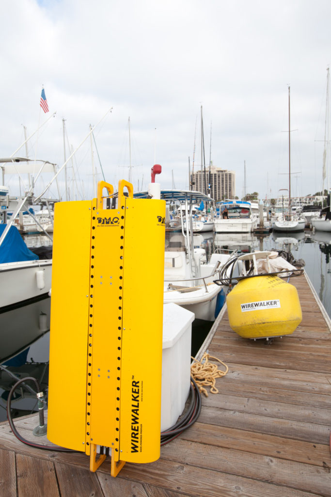
DMO – Del Mar Oceanografic, LLC, San Diego, CA, USA
THE WIREWALKER™
Vertical profiler: Powered by ocean wave energy.
Here's how it works: A length of cable is suspended from a small floating surface. At the deep end of the cable, a weight drives the entire length of cable to move vertically, following the oscillatory
motion of the surface float. The Wirewalker™ profiler travels along the cable, with an internal cam gripping the cable as it descends and releasing as the cable ascends. At the bottom of the desired profiling
range, the profiler collides with a mechanical "stop" that releases the cam, allowing the Wirewalker™ to ascend freely to the top of the cable under its own buoyancy. top of the wire under its own buoyancy.
Here, the cam is reset and the cycle repeats.
The Wirewalker™ is designed to be simple in operation, robust to harsh conditions and highly configurable by use. By transforming the energy from the surface wavefield to the profiling motion of the
vehicle, the on-board batteries are used exclusively to power the instrumentation. From conductivity, temperature and pressure measurements, to optical, ocean current and turbulence measurements, the Wirewalker
™'s smooth ascent enables high-quality data collection from any fast-sampling oceanographic sensor.
Features of the Wave-Driven Wirewalker Profiling System:.
- Wirewalker profiler with flotation tested for 300 m depth.
- Buoy system with strobe lights, mooring system.
- Real time telemetry system.
- Fluorescence TURNER kit for Chlorophyll-a.
- CDOM fluorescence TURNER kit.
- Bio-fouling cleaning brush.
- Quantametro Licor 192SA.
- Datalogger RBR Cervello with GSM, battery pack.
Website: http://www.delmarocean.com/

EIVA Marine Survey Solutions, Skanderborg, Dinamarca
Lowest possible total cost of ownership in the market, through competitive purchase price coupled with low service and communications costs. Advanced integrated ADCP and advanced waveform sensor, provide
highly accurate current data; configuration and transmission are adjusted according to your needs, keeping communications costs to a minimum as well.
From harbor monitoring, subsea engineering surveys to wave energy surveys and any type of wave and current measurement surveys, ToughBoy Panchax is the optimal choice. Additional sensors can be installed
as optional extras, creating a wave buoy that perfectly fits the configuration you are looking for.
Website: https://www.eiva.com/products/eiva-equipment/toughboy-panchax?gclid=EAIaIQobChMI19KBxYD
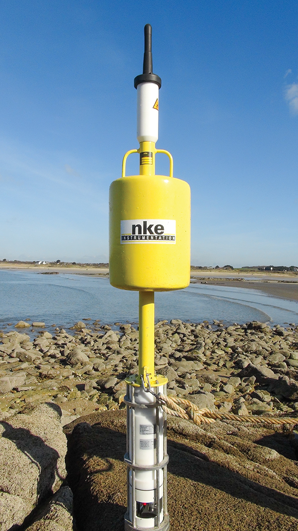
NKE Instrumentation, Hennebont, Francia
- Low consumption autonomous system: battery and solar panel.
- Data transmission by radio link or cellular phone network via TCP-IP protocol, secure transmission.
- Large data storage capacity in the buoy (more than 1 year).
- Retrieval and archiving of data in the field on the computer, link to the client's network.
- Possibility of instrumentation for the measurement of water parameters: Temperature (multisensor chain or fixed point), currentometry (integration of a Doppler acoustic profile current meter), Water
level (with atmospheric pressure compensation), Conductivity, Dissolved Oxygen, Turbidity, pH, Chlorophyll.
- Meteorological: wind speed and direction, air temperature.
In 2005, for EDF, NKE implemented 2 instrumented buoys in the Gironde estuary to monitor the temperature of the discharge water of the Blayais nuclear power plant.

NKE Improved profiling buoy of the initial model PROLIPHYC
It measures continuously physico-chemical water parameters and meteorological parameters involved into phytoplankton proliferation. Designed for anchoring in inland water bodies.
It is equipped with an overhead gantry, made of aluminum, which integrates:
- An automaton: automates buoy control, sensor management, GSM / GPRS communication; it integrates, in an IP66 marinized box, the controller card and its integrated software, the card. control card,
the GSM / GPRS (SIM card), "Socapex" type connectors for connecting equipment.
- A 68W solar panel, solar panel regulator and 2 batteries of 33Ah.
- A low consumption winch, with 20 m stainless steel cable, ensures the movement of the basket of instruments: multiparametric probe (temperature, pressure, conductivity, DO) and FluoroProbe BBE 5 wavelengths
(450, 525, 570, 590 and 610 nm) and the operation of the chlorination system.
- A "basket" end-of-travel sensor to calculate the length of the cable turned by the winch.
- A "bottom" end-of-travel sensor (cable completely unwound).
- A sunlight irradiance sensor (Kip and Zonen type).
- A Vaisala weather station measuring wind speed (ultrasonic sensor) and wind direction, temperature and atmospheric pressure, rainfall.
- A NKE compass, to determine wind direction.
- A chlorination system.

YSI EMM68 - Harbour
Rapidly deployable water quality monitoring platform with remote telemetry. The system comprising only the buoy and solar panels can be lifted by two people. It is fully operable from a small boat.
Features:
- Deployable from the shore.
- Remote telemetry.
- Uses: construction and dredging monitoring.
- Rapid response in emergencies.
- Usable without a diver.
Specifications:
- Weight: 48 kg in the air.
- Payload: Any YSI multiparameter water quality probe.
- Solar panels: Power 2, 12 v / 24 amp-hr battery.
Website: http://www.ysiisa.com/
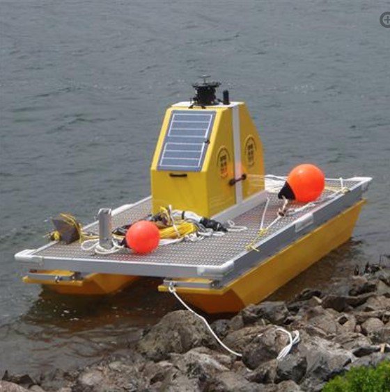
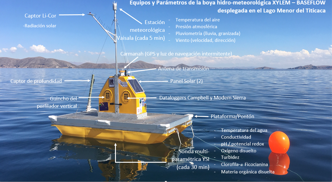
XYLEM HydroMet Profiler Pontoon/Raft
Lowest possible total cost of ownership in the market, through competitive purchase price coupled with low service and communications costs. Advanced integrated ADCP and advanced waveform sensor, provide
highly accurate current data; configuration and transmission are adjusted according to your needs, keeping communications costs to a minimum as well.
From harbor monitoring, subsea engineering surveys to wave energy surveys and any type of wave and current measurement surveys, ToughBoy Panchax is the optimal choice. Additional sensors can be installed
as optional extras, creating a wave buoy that perfectly fits the configuration you are looking for.
Website: http://www.baseflow.net/
What parameters does 'My Buoy' measure?
The Vaisala 202133 weather station is equipped with a suite of all-digital sonic sensors with no moving parts. It measures 5 of the most essential weather parameters and solar radiation:
- Speed (range 0-60 m/s, response time 0.25 s, available variables: average, maximum and minimum, accuracy ± 3% at 10 m/s, resolution 0.1 m/s) and wind direction (azimuth 0-360º, response time 0.25 s, available
variables: average, maximum and minimum, accuracy ± 3% at 10 m/s, resolution 0.1 m/s). 0.25 s, available variables: average, maximum and minimum, accuracy ± 3.0º at 10 m/s);
- Duration (counting each 10-second increment each time a drop is detected, resolution 10 s; hail: cumulative amount of hits against the collection surface, duration: counting each 10-second increment when
hail is detected, resolution 10 s; hail: resolution 0.1 hits/cm2, 1 hit) and precipitation intensity (cumulative accumulation after the last automatic or manual reset, running average of 1 min in steps of 10 seconds, observation
range 0-200 seconds, resolution 0.1 hits/cm2, resolution 0.1 hits/cm2, 1 hit) collection area 60 cm2, output resolution 0.01 mm, accuracy better than 5% depending on weather; intensity: running average of 1 min in steps
of 10 s, hail resolution 0.1 hits/cm2, 1 hit); intensity: running average of 1 min in steps of 10 s, hail resolution (0.1 hits/cm2h, 1 hit/h);
- Barometric pressure (range 600 to 1100 hPa, accuracy ± 0.6 hPa from 0 to +30°C): Barometric pressure is the atmospheric pressure value measured at any point above sea level.
- Relative Humidity (0 to 100% RH, accuracy ± 3% RH at 0-90% RH, +5% RH at 90-100% RH): Relative Humidity (RH) is the ratio of the partial pressure of water vapor to the equilibrium vapor pressure of
water at a given temperature. equilibrium vapor pressure of water at a given temperature.
- Air temperature (-52º to +60ºC, accuracy to +20 ºC ± 0.3ºC): Temperature is an index indicative of the heating or cooling of the air resulting from heat exchange between the atmosphere and the earth.
- Incident solar radiation using a Li-200 R pyranometer sensor (accuracy 5%, typically.
< 3%, sensitivity ± 1% linearity). : Solar radiation is the set of electromagnetic radiations emitted by the Sun. Solar radiation is distributed from infrared to ultraviolet. Not all radiation reaches the surface of the Earth's surface, because the shorter
ultraviolet waves are absorbed by gases in the atmosphere.
The YSI EXO2 multiparameter sonde is the most advanced platform for water quality monitoring. It has a
depth range of 0-250 m, an autonomy of 90 days with an acquisition rate of 15 min and a frequency of up to 4 Hz. It houses 7 ports, 1 for the antifouling cleaner and 6 for sensors:
- temperature (accuracy 0.001 mS/cm and resolution 0.0001 to 0.01 mS/cm): The electrical conductivity of water also depends on the temperature of the water: the higher the temperature, the higher
the electrical conductivity. The electrical conductivity of water increases by 2-3% for a 1 degree Celsius increase in water temperature.
- pH/ORP(range -999 to 999 mV, accuracy ± 20 mV, resolution 0.1 mV): pH is a measure of acidity or alkalinity indicating the amount of hydrogen ions present in a solution or substance. ORP is a
measure of the reducing and oxidizing capacity of the material.
- chlorophyll-a and phycocyanin (cyanobacteria) combined in a single sensor (range 0 to 100 µg/L, resolution 0.01 µg/L): Cyanobacteria, formerly called blue-green algae, are a phylum of the Bacteria
domain comprising bacteria capable of oxygenic photosynthesis. They are the only prokaryotes that carry out such photosynthesis, hence they were also called oxyphotobacteria.
- fDOM (dissolved organic matter fluorescence; more accurate proxy than CDOM, colored dissolved organic matter) (range 0 to 300 ppb QSU - Quinine Sulfate Equivalents, detection limit 0.07 ppb QSU, resolution
0.01 ppb QSU): Dissolved Organic Matter/Dissolved Organic Molecule comes either from the degradation of dead organisms, or from the excretion of living organisms (plankton).
- Optical DO, dissolved oxygen (range 0 to 50 mg/L, accuracy 0 to 20 mg/L ± 0.1 mg/L i.e. 0.1 % of reading, and 20 to 50 mg/L ± 5% of reading, resolution 0.01 mg/L): Dissolved oxygen (DO) is the
quantity of gaseous oxygen that is dissolved in water. Free oxygen is essential for the life of fish, plants, algae, and other organisms; therefore, it has long been considered an indicator of a river's ability to support
aquatic life.
- Turbidity (range 0 to 4000 FNU, accuracy 0-99 FNU with 0.3 FNU or ± 2% of reading, 1000 to 4000 NFU with ± 5% of reading, resolution 0-999 FNU = 0.01 NFU, 1000-4000 FNU = 0.1 FNU): Turbidity is
a measure of the degree to which water loses its transparency due to the presence of suspended particles; turbidity can impact aquatic ecosystems by affecting photosynthesis (limiting the passage of sunlight), respiration,
and the reproduction of aquatic life.
How does 'My Buoy' work?
The XYLEM catamaran pontoon (with two hulls) is much more stable than a classic buoy in windy conditions and swell, quite frequent in Lake Titicaca. Even in these conditions it allows to work on board, program, calibrate
and repair equipment. It houses 2 solar panels oriented in opposed positions capable of generating all the electrical energy necessary for the permanent operation of the equipment, and the Vaisala sonic weather station
(without moving parts) in the upper mast, and in the central compartment the vertical profiler (cable wrapped around a winch) to which YSI EXO2 submersible multiparameter sonde is suspended.
The data generated by both sensor systems are stored into two Campbell CR1000 dataloggers (one for the multiparameter sonde and the other for the weather station), and transmitted wirelessly via the Internet by means
of a Sierra Airlink modem. The frequencies of data acquisition as well as of vertical profiling are fully programmable, with minimums of 5 min and 1 hour, respectively. The pontoon is equipped with a Garmin GPS 16X-HVS (high sensitivity, 12 channels, NMEA 0183 output) to detect any drift linked, for example, to the breakage of one of its two moorings, as well as a radar display and Carmanah M650 beacon with high power LED lights with a 4-mile range for nighttime collision avoidance. Various software allow to synchronize the sensors with each other and to program the emission of their data (LoggerNet), program and analyze the profiled data
(YSI Profile Wizard and custom written firmware CR1000 Turn Key System) and generate automatic alerts in case threshold values are exceeded.
'My Buoy' is an XYLEM profiling pontoon