UNDP PILOT PROJECT 05-B-05 (2019-2021):
Lake Titicaca permanent Observatory (OLT).
The UNDP/GEF Pilot Project 05-B-05 'Lake Titicaca permanent Observatory' is one of the eleven pilot projects (five in Bolivia and six in Peru) that make up the TDPS Binational IWRM Project (Integrated Water Resources Management of the Titicaca-Desaguadero-Poopó-Salar de Coípasa Water System;
https://girh-tdps.com/proyecto-piloto-05/). This is funded for three years (2019 to 2021) by the GEF (Global Environment Facility) and administered by the UNDP (United Nations Development Programme). Pilot 05-B-05 is a scientific cooperation between staff and associate researchers from the Institute of Ecology (IE) and the Institute of Geographical Research (IIGEO),
both from the Mayor University of San Andres (UMSA) and researchers from the French Institute of Research for Development(IRD).
The practical goal of this pilot is to support the decision making of the UGCK/MMAyA (the Katari Watershed Management Unit of the Ministry of Enviroment and Water), the Cancilieria (Ministry of Foreign Affairs),
the SENAMHI (National Service of Meteorology and Hydrology) and the ALT (Autonomous Binational Authority of Lake Titicaca), among other institutions, over the assessment of the status, conservation, management and
restoration of Lake Titicaca, with reliable updated information and data of quality from research and monitoring.
Its function is also to anticipate the future evolution of the ecosystem of the Minor Lake Titicaca, which is among the most vulnerable because it is so shallow and so populated, due to the combination of the strong impacts
of climate and anthropogenic change. The combination of strong climate change and anthropogenic change: in particular the intensification of extreme events (drought, rains) out of season, combined with the deterioration of the
environment and multiple pollution of domestic, industrial, agricultural and/or mining origin, plus industrial, agricultural and/or mining pollution.
Objectives
The UNDP/GEF 05-B-05 pilot project aims to understand the biogeochemical and ecological functioning of the shallow northern and central regions in the Bolivian section of the Minor Lake Titicaca heavily impacted by the combination of intense climate change and increasing anthropogenic pollution from the Katari River basin. The development of the scientific investigations is based on three monitoring strategies: (a) an automated high frequency monitoring (minutes, hours) and real-time data acquisition by aa hydrometeorological buoy (HydroMet), anchored in a 10 m depth zone, integrating the dynamics of the most populated northern region, (b) a routine sampling program over a network of shallow (< 5 m) littoral stations directly influenced by pollution and (c) a remote satellite sensing which allows a multi-temporal analysis of the water condition at the global scale of Minor Lake.
Description
From this new base of updated knowledge acquired on a permanent and long-term basis, it will be possible to visualize the spatio-temporal evolution of the water condition and identify the most vulnerable areas where intervention would be needed. Thus, an early warning system of water quality deterioration (eutrophication) will be implemented. In particular, it will aim to anticipate the proliferation of phytoplankton micro-algae blooms, which are extremely harmful to the aquatic environment and the hydrobiological resources that are a source of life for the riparian populations. In fact, these blooms generate anoxia (drastic reduction of dissolved oxygen in the water column), which can cause massive mortality of fish, frogs and even waterfowl, accompanied by unpleasant odors and a bluish-green coloration of the water surface, as first reported in April-May 2015. Anticipation of such phenomena may allow time to take measures capable of mitigating the magnitude of their devastating consequences for the proper ecological functioning of the lake and human activities.
Scope of intervention
Lake Titicaca (8,400 km2 in area and 930,106 km3 in volume) is the largest freshwater lake in the South American continent. It is also the highest of the Great Lakes and a hotspot of plant and animal biodiversity and endemism. For these reasons, in addition
to its sacred character and for having sheltered such valuable ancestral civilizations, it is unique and must be cared for with great respect. Thanks to Lake Titicaca, in the northern Altiplano there is a microclimate with a moderate
and humid climate, which allows life and the development of productive activities, such as agriculture and livestock.
Due to its tropical location (16ºS) and its high altitude (3,809 m above sea level), Lake Titicaca and its watershed are impacted by the intense effects of climate change. Projected warming will be twice the average warming
for the planet. That is, if the planet average increase by 2ºC until 2100, warming over the lake and the Altiplano will exceed 4ºC. The seasonality between dry and rainy periods will also be altered, with an increase in the occurrence
and intensity of extreme events (drought, floods).
The focal site of this study was selected to integrate the Bolivian sector of the northern and central regions of Minor Lake, which are more populated and directly or indirectly influenced by wastewater discharges from the
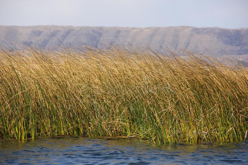
urban area of El Alto (1.2 million inhabitants) through the Katari river basin. These waters carry multiple contamination, between domestic, industrial and mining, to the central and southern canals of Cohana Bay, between the Totora
(cattails), and also to the north via the Cumana Bay. During the rainy season, the Katari and Sehuenca rivers overflow from their beds, form flood lagoons, and carry cones of contamination and sediment where they flow through the
Cumana Bay into the lake (see Fig. 1).
To integrate these influences, on June 27, 2019, we anchored the HidroMet buoy, at the deepest center (~10 m) of the northern region, 4 km south of Huatajata and 12 km northwest of Puerto Perez. Its georeferenced location
is: 16º 14.7944' S and 68º 40.8103' W (see Fig. 2).
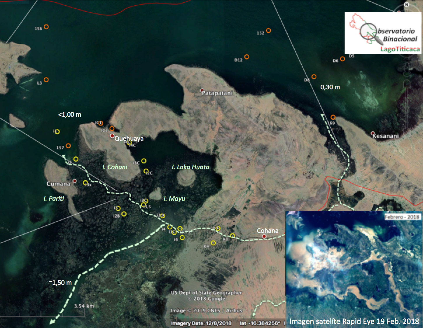
Figure 1 - Map of the 3 tributaries of the Katari River. Two tributaries carry wastewater from the Katari basin to the central and southwest channels of Cohana Bay, among the cattail reeds. The third tributary carries them to the northern region of Minor Lake, via Cumana Bay. The red and yellow circles locate some of the stations of the routine monitoring network. X. Lazzaro elaboration, modified from Google Earth ©. In the lower right corner, the satellite image shows the overflow of the Katari and Sehuenca rivers, carrying sediments and pollutants into Minor Lake.
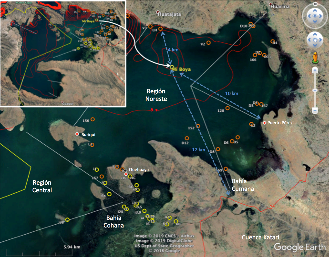
Figure 2 - Map of the study site in the Bolivian sector of the northern and central regions of Minor Lake. The Katari basin, Cohana and Cumana bays, and the location of the HydroMet buoy are shown. X. Lazzaro elaboration, modified from Google Earth ©.
Strategies
This pilot project represents the first permanent observatory (OLT) of Lake Titicaca. It uses the most advanced approaches and equipment in terms of technological innovation. The HydroMet buoy is the first autonomous high-frequency (minutes, hours) automatic
hydrometeorological monitoring buoy with real-time remote data transmission deployed in Lake Titicaca. Since then, Lake Titicaca has a long-term monitoring and research program, like the other Great Lakes.
The pilot project combines research on the mechanisms of eutrophication (i.e., the proliferation of micro-algae due to excessive inputs of nutrients – nitrogen and/or phosphorus – and organic matter) under conditions of a shallow,
tropical, high-altitude lake with a water quality monitoring program based on three monitoring strategies:
1) A high frequency monitoring (minutes, hours) in near real time of key eutrophication parameters, at a fixed location central to the study area (northeast and central region), by means of a hydrometeorological buoy (Fig. 3). (northeast and central region), by means of a hydrometeorological buoy (Fig. 3). This location was selected because it is impacted by a combination of climate change and anthropogenic effects (exogenous inputs). effects (exogenous inputs of nutrients and organic matter, as well as pollutants and sediments). This monitoring is focusing on identifying the mechanisms and sequences of extreme events, such as blooms of phytoplankton microalgae. phytoplankton microalgae blooms, in order to implement an early warning system..
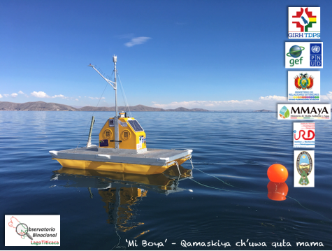
Figure 3 - HydroMet pontoon buoy, equipped with a weather station (at the top of the mast), a multiparameter probe (below the surface) attached to a winch for vertical profiling in the water column, and two solar panels for autonomous operation. the water column, and two solar panels for autonomous operation. Photo X. Lazzaro.
2) Periodic monitoring based on measurement and collection campaigns with a frequency of 5-10 days over a network of limnological stations located in representative areas particularly vulnerable to eutrophication. They are arranged along transects (gradients) from pollution sources (e.g., the mouth of the Katari River in Cohana Bay) to open water, or arranged along transects (gradients) from pollution sources (e.g., the mouth of the Katari River in Cohana Bay) to open water. or arranged along the coastline in front of point sources (e.g. villages, activity centers...) or diffuse sources (e.g. agricultural and livestock fields...) of pollution. Its objective is to identify areas in a state of eutrophication, in order for the institutions responsible for policies to implement mitigation measures.
3) A global scale monitoring of Minor Lake by satellite remote sensing, with a spatial resolution of up to 10 m, validated by in situ measurements of chlorophyll-a concentrations of phytoplankton, distribution, density and status of totora, among other relevant parameters of the eutrophication status.
The generated databases are stored in a UMSA server and shared through the information system (IS) of a spatial data infrastructure (GeoVisor) designed to different users, such as decision makers (e.g., from MMAyA, SENAMHI and ALT) and identified scientific researchers (e.g., from UMSA, and other universities), as well as more globally with the civil society. Socializing the knowledge generated globally, in rural and urban areas, in schools and educational programs (TV, radio, newspapers) is essential to raise awareness for the care of this natural and cultural wonder.
Beneficiaries
The beneficiaries of the pilot project are the shore dwellers (e.g. farmers, fishermen, cattle ranchers, boatmen, tourism agents, etc.) who enjoy the eco-systemic services provided by the lake, as the results of the monitoring will allow for targeted actions to be taken to ensure the conservation and restoration of this water body.
Expected results
Outcome 1: Improved knowledge of the biogeochemical and ecological dynamics in the Lesser Lake Titicaca from data generated by the HidroMet buoy (high frequency), routine monitoring campaigns,
and satellite remote sensing.
Outcome 2: Establish relationships between parameters, bio-indicators and particular phenomena identified to prevent or at least anticipate the appearance of micro-algae blooms and other phenomena
of great relevance for the life and services provided by Lake Titicaca to the populations.
Outcome 3: To train UMSA academic and technical personnel from MMAyA, SENAMHI and ALT in the collection and interpretation of monitoring data for decision making and socialization of the information
generated with local communities.
Outcome 4: Develop technical and scientific reports.
Outcome 5: Publish technical and scientific articles.
Ventusky - live weather
Ventusky web is an application of the Czech Weather Company. It allows observing weather conditions in real time, also in the past and one week in advance. The weather data providers are DWD and NOAA. The modeled variables are: precipitation modeled are:
precipitation, clouds, wind speed/direction, atmospheric pressure, thunderstorms humidity, waves, snow cover, air quality, among others.
Double clicking on the image will take you to the visualization of the lake with the program on the web: ventusky.com, where you can select the variable of interest.
Enjoy....


Partners / Researchers
BOREA / IRD:
Xavier Lazzaro , coordinator of the UNDP 05-B-05 pilot project
BOREA / IRD, lake ecologist
xavier.lazzaro@ird.fr
GET / IRD:

David Point
GET / IRD, biogeochemist
david.point@ird.fr
Anthony Gautier
AG, micro entrepreneur,
a.gautier.fr@gmail.com
IE / UMSA:
Dario Achá Cordero, co-coordinator
IE / UMSA, micro biologist
darioacha@yahoo.ca
Carlos Molina Arzabe
IE / UMSA, aquatic ecologist
camoar6088@gmail.com
William Gustavo Lanza Aguilar, research associate
IE / UMSA, planktonologist
wilanz66@gmail.com
Viviana Edith Cruz Hernández, research associate
IE / UMSA, planktonologist
vchrz11@gmail.com
IIGEO / UMSA:

Javier Nuñez Villalba, co-coordinator
IIGEO / UMSA, geographer - remote sensing specialist
jnuñezvillalba@gmail.com
Javier Alberto Maldonado Alfaro, research associate
IIGEO / UMSA, biologist-geographer specializing in remote sensing
javier.maldonado.alfaro@gmail.com

Jhasmin Duarte Tejerina, research associate
IIGEO / UMSA, geographer- remote sensing specialist
jhass.geo95@gmail.com

Mishel Justiniano Ayllón, research associate
IIGEO / UMSA, geographer- remote sensing specialist
misheljustinianogeo@gmail.com
Jose Luis Soza Santos
IIGEO / UMSA, geomatic - web master of GEOVISOR/IIGEO
jsozasantos@gmail.com

Marcela Andrea Ormachea Rojas, research associate
IIGEO / UMSA, Lake Titicaca Observatory web master of Lake Titicaca Observatory
andremar985@gmail.com
Cooperators in Huatajata:
Erik Catarí Gutiérrez, local cooperator, Huatajata
Entrepreneur
erikcatarig@gmail.com
Maximo Catarí Cahuaya, local cooperator, Huatajata
Entrepreneur
Cooperator in Quehuaya:
Oscar Limachi, local cooperator, Quehuaya
Tourism agent
Cooperator in Puerto Perez:
Isaac Callizaya Limachi, local cooperator, Puerto Pérez
Secretary of the environment
islapariti21@gmail.com
BOREA - Laboratoire Biologie des Organismes et Écosystemes Aqutiques, Paris, Francia.
GET - Géosciences Environnement Toulouse, Toulouse, Francia.
IE - Instituto de Ecología, campus UMSA, Cota Cota, La Paz.
IIGEO - Instituto de Investigaciones Geográficas, campus UMSA, Cota Cota, La Paz.